Severe Storms Track From Mamou into Kindia
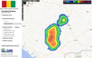
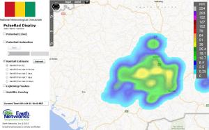
23 April 2014, 18:30 UTC: Meteorologitsts monitored strong thunderstorms which developed on Wednesday afternoon in the Mamou highlands and plodded westward into Kindia by early evening. The Guinea Meteorological Directorate used simulated PulseRad radar powered by the countrie’s total lightning network to track the powerful storms.

These storms had produced 25 – 50 mm of rainfall across the region in rainfall rates that exceeded 2″/hour at times.

The storms with frequent lightning and heavy rain were also likely producing gusty winds as the moved through the hill country of Kindia toward the city of Fria. Also, the lightning intesity that was measured in the storm caused Dangerous Thunderstorm alerts to be issued for two of the more potent areas of storms.

These storms are forecast to continue to slowly move west over the next several hours but will weaken as they approach the coast.


