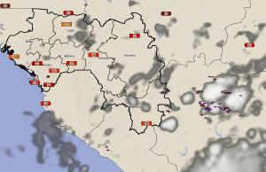
Ivory Coast Rain Signals Cooler, Wetter Period
16 May 2014, 1530 UTC: Slow moving, heavy thunderstorms over the Ivory Coast today have been dumping rainfall of 15 – 30 mm over the northern parts of the country this afternoon. Overnight and early morning thunderstorms over Guinea also dropped similar amounts of rain, but had since mostly diminished; giving way to warm humid conditions over much of the country.

This afternoon, the total lightning detection network was tracking an area of heavy storms in Ivory Coast that would move into southern Guinea tonight.

This impulse of instability is being tracked by Guinean meteorologists as this area will affect the country over the next two to three days, bringing cooler temperatures and high probablilities for periods of thunderstorms and heavy rainfall. Forecasts generated by the Guinea ENcast Forecast System for both Fria and Debola show the cooling trend of 4-8 degrees occurring over the next few days.


